World Meteorological Organization
FORMAT TO PROVIDE SEA ICE DATA FOR THE WORLD CLIMATE PROGRAM
(SIGRID-2)
Content
Annex 2 Transformation of Graphic ice chart into the SIGRID-2 format
In accordance with the decision of CMM-X to support the World Climate Program in the questions related with sea ice the SIGRID format has been developed and presented in 1989 as an Annex to Part II of the Manual for Marine Meteorological Services. Within that document an attempt has been made to create a universal format aplicable both for data exchange for the climatic studies and to resolve the operational tasks. Therefore, two techniques for digitizing graphic ice charts, namely grid coding and contour (vector) coding, and the code variables not in fact required for the Climate Program were included in the format, thus resulting in unnecessary complication of the conversion procedure. The experience gained in the past years has shown both variants to have definite shortcomings. The main shortcomings for the grid coding version planned directly for the Climate Program are as follows:
The shortcomings of the SIGRID Format and the proposals for its improvement were discussed at the meeting of the Steering Group of the WMO Project "Global Sea Ice Data Bank" (St. Petersburg, Russian Federation, 20-24 July, 1992). After discussion, the participants of the meeting agreed with the analysis of the SIGRID Format shortcomings, presented by Prof. A.V.Bushuyev (Arctic and Antarctic Research Institute (AARI), Russian Federation) and requested him to develop an abridged version of the format. The major amendments included recommendations to leave only Tables 1, 2, 4, 5, 14 and 15 in the description of the SIGRID Format , which corresponds to the WCRP requirements and the capabilities of the current measuring equipment. The representatives of the WDC-A also suggested to include the tables of the surface temperature and the albedo of the underlying surface and agreed to develop a respective section of the format.
During autumn 1992 a draft version of the format (SIGRID-2) was prepared by Prof.A.V.Bushuev, revised by Prof.R.G.Barry (WDC-A for Glaciology) and sent to several National Ice Services via WMO. Further work on the SIGRID-2 proceeded at the next meeting of the Steering Group (Suitland, Md, USA, 4-6 October 1993). Based on decisions of CMM XI and results of discussion participants agreed to develop the revised version of the SIGRID-2 document after incorporating recommendations proposed both at the meeting and in materials received. All reviewers namely from the Danish Meteorological Institute, Japan Meteorological Agency, USA National Ice Center and World Data Center A for Glaciology agreed that the shortened version of the format is more practical and user friendly than the full SIGRID. At the same time the proposed amendments concerned firstly, preservation of some old identificators and including new ones, namely - stages of melting, air temperature over the ice, snow on ice properties, floesize and presence of navigable leads and secondly, rules of griding and averaging data. All proposals were considered while updating the SIGRID-2 document at AARI. Description of data not primarily intended for use in climatology e.g. presence of navigable leads was not included in the format. Coding of such information may be implemented using the previous SIGRID version or universal coding format CONTOUR, directly intended for navigation purposes and presented to WMO by AARI.
The revised version of the SIGRID-2 is described below. Taking into account that the National Ice Services have carried out a specific amount of work to introduce the SIGRID Format, the prepared SIGRID-2 preserves, whenever possible, the general layout of the data, some identifiers, indicators and other symbols from the previous version of the SIGRID format.
It is assumed that in order to provide information for the World Climate
Program, the exchange of archived data between the Ice Services and Data
Banks will be by means of mailing the registered digitized ice charts on
magnetic tape (in practice magnetic tape can be substituted by floppy diskettes
or optical disks). It is desirable that each tape should include a set
of uniform ice charts from one Ice Service, covering approximately one
and the same region. Spatial coverage of the included ice charts is not
restricted, that is, information on a separate chart may correspond to
two quadrants and the number of points on one gridding line may be up to
1440.
Each tape should include the Header File, the Chart Data File and the indicator of the end of the recorded information(END). Subsequently, each Chart Data File includes Header Record, information, identifying grid lines and data groups, a separate block describing the ice drift (if the data are available) and the indicator of the end of a given Chart Data File (:99:99:99).
It is recorded in the following format
SIGRID-2
AAFF:NNN
Q1M1M1L1L1L1 Q2M2M2L2L2L2 AQ0M0M0L0L0L0
J1J1J1Y1Y1D1D1-J2J2J2Y2Y2D2D2
where:
: - separating symbol; AA - originating country; FF - originating Service; NNN - total number of digitized charts on the tape; MM and LLL - with the indices 1 and 2 - minimum and maximum latitude and longitude of the observation region in degrees; Q - indicator of the hemispheric latitude and longitude (1 - East, 2 - West for the Northern Hemisphere; 3 - East, 5 - West for the Southern Hemisphere); A - identifier group;
QM0M0L0L0L0 - latitude and longitude of the initial point of the geographical grid; JJJYYDD with the indices 1 and 2 - year (thousand is rejected), the month and the day of the first and the last chart by time, recorded on the tape.
After coding the obligatory information, if necessary, any other data required for the correct data use and pertinent to the whole tape is included as a free text.
Each file of an individual ice chart, recorded on a magnetic tape, starts with the Header Record
SIGRID:NNN
Q1M1M1L1L1L1 Q2M2M2L2L2L2 Q3M3M3L3L3L3 Q4M4M4L4L4L4
J1J1J1Y1Y1D1D1-J2J2J2Y2Y2D2D2 FNmNmNm
EP1P1R1N1P2P2R2N2......PnPnrnnn
where:
: - separating symbol; NNN - serial number of the chart on the tape; QMMLLL with the indices 1 - 4 - geographical coordinates (quadrant and degrees of the latitude and longitude) of a closed rectangle, contouring the observation region; JJJYYDD with the indices 1 and 2 - year, month, date of the start and end of the observations which have been used to construct a chart; F - identifying letter (identifier) of the group; NmNmNm - serial or archived number of the chart (defined by the National Center); E - identifier of the group, defining the methods and means used for entire data collection to plot the ice chart; PP - observation methods and means (code table 7); r - meaningful resolution figure at the site in meters; n - power indicator 10.
Thus, resolution of the observation methods and means is determined by the expression R = r*10^^n. If resolution is not defined then it is coded by 99. Note, that after identifier DI spatial error of data interpolation is coded.It is recommended to use the identifier DI for charts based only on aircraft route survey. After identifiers DA and DP, marking whether data are averaged for grid mesh or given as actual values at grid point, the digit code is not given.
For example, an airborne radar survey with a resolution of 7 meters
at the site will be coded as EAR70. Satellite observations in the IR range
with a 1 km resolution, visual observations from aircraft with undefined
resolution and successive averaging to mesh size will be coded as EPI13AR99DA.
If some additional sources or observation methods and means with other
spatial resolution were used for collecting data at definite points it
is recommended to define such information separately inside the respective
data group in the lay-out after the prime identificator. For example,if
spatial position of the definite group corresponds to the exact position
of the aircraft survey route with navigation error 10 km then total concentration
may be coded as CTAV14. The Header-Record of the ice chart can be used
as a base file of the ice chart identifiers, allowing a search for the
required data by the observation region and time, at the request of the
users.
The data, contained in the ice chart, is converted into a grid format by superimposing the points onto a contour graphic or digital chart and assigning to each point a set of variables and their numerical quantitative values, determined for the zone, where a given point is located. The grid points are situated on the lines, having one and the same latitude (parallels). The interval between the grid lines along the meridians is constant, being equal to 15', counted out from the whole value of the latitude degrees. Thus, on a single one-degree strip the grid lines are at the parallels:
MM000'; MM015'; MM030'; MM045',
where MM - a whole value of the latitude degrees.
In order to provide linear change in the distance between the grid
points, situated on neighboring latitude lines with an increment ratio
not exceeding two, for each latitude interval from the equator to the pole
a longitude/latitude ratio is established, changing from 1 at the equator
to 120 at the latitude 89 45'. For the grid lines located at latitudes
more than 890, the condition of the whole number of the cells within 3600
is an additional criterion, that is why the distance at these lines is
assumed to be 150 and 300, and not 160 and 320 (Table 1).
Table 1. Distance between the grid points on the lines in degrees and linear (nautical miles) measure
| Latitude interval | Ratio | Dist. in longitude degrees | Max.dist. in miles | Min.dist. in miles |
| 00 00' - 59 45' | 1 | 0 15' | 15.00 | 7.56 |
| 60 00' - 75 45' | 2 | 0 30' | 15.00 | 7.38 |
| 76 00' - 82 45' | 4 | 1 00'. | 14.52 | 7.57 |
| 83 00' - 86 15' | 8 | 2 00'. | 14.62 | 7.85 |
| 86 30' - 88 00' | 16 | 4 00'. | 14.65 | 8.38 |
| 88 15' - 89 00' | 32 | 8 00'. | 14.65 | 8.37 |
| 89 15' - 89 30' | 60 | 15 00'. | 11.78 | 7.85 |
| 89 45' - 90 00' | 120 | 30 00'. | 7.86 | - |
For a complete coincidence of the grid points from the different charts the distance on the lines in degrees indicated in Table 1, should be strictly observed, although the coded digitized chart contains an indication of the longitude/latitude ratio for each line, which controls the correctness of the data entering. The lines of the geographical grid of each chart are numbered towards increasing latitude (from south to north in the Northern Hemisphere and from north to south in the Southern Hemisphere), and the grid points on the lines - from west to east, in both the Northern and Southern Hemispheres. The read-out is from the initial point, to which the number 001001 of the given chart (magnetic tape) set is assigned. The geographical coordinates of the initial point are reported in the Tape Header File. The latitude of the initial point is chosen from the data on the minimum latitude (the closest least whole degree is taken). The longitude of the initial point is selected on the basis of the data on the minimum longitude and maximum latitude of the observation region.
In order that the corresponding grid points of different charts have one and the same longitude, the initial point longitude is assumed to be equal to the closest smallest one, divisible to the distance between the points on the line, having a maximum latitude. However, if the observation region of the set of the charts on the tape includes the Pole, the initial point longitude is assumed to be equal to 80, rather then 300.
For example, if the minimum longitude equal to 55 00'E is on latitude 68 45'N and maximum latitude is 86 30'N, then the longitude of the initial point should be equal to 52 00' and its coordinates will be A168052.
A rectangle, in the center of which there is a grid point, restricted by meridians and parallels, dividing the distance between the adjacent points by half, is called the grid mesh. For example, the left bottom and the right top angles of the mesh, the coordinates of the central point of which are 68 15'N and 136 30'E will be 68 07.5', 136 15', 68 22.5' and 136 45' (see Fig.1).
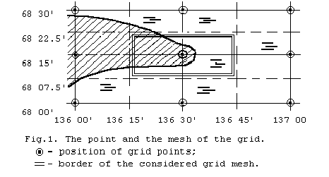
The conversion of sea ice data, presented in the form of a contour chart, into data in geographical grid points, is carried out by a successive scanning along the grid lines in the direction from the equator to the pole (north or south) and from west to east. Each grid point, as indicated, is assigned the value of the variables of that zone where the point lies. Thus, if no additional processing is done, the grid variable appears to be the actual value at the chart point with respective geographical coordinates, rather than an averaged value for the grid mesh, although the information, defining the ice in the grid point is considered to be representative for the entire mesh. Thus, for Fig.1 the value of the variables in the shaded zone is assigned to the grid point and therefore to the entire mesh although the largest part of the mesh refers to water free of ice. That is why the dimensions of the zones at the chart scanned should be more than 15-20 nautical miles across. Hence, a preliminary generalization of large-scale ice charts is recommended. If done, the level of data generalization should be defined in the Header Record (code table 7).
The information on the location of each scanning line and points, which get into the boundaries of a specific chart and data groups, describing the ice cover on this line, belongs to a separate block. A block starts with the data which are recorded on a separate line and defines the longitude/latitude ratio of the grid meshes and coordinates of the initial line point, relative to the initial tape point (the geographical coordinates of which are given in the Tape Header File) in the following form:
=Kll:Lmmmppp:MNpNpNpNp:XRnRnRnRn
where:
= - symbol, indicating the start of the data block recording on the line; K,L,M,X -identifiers (identifying letters of separate data); ll - longitude/latitude ratio on the line; mmmppp - coordinates of the initial point (line number, point number), calculated from the initial point, the coordinates of which are 001001; NpNpNpNp - number of the grid points on the line; RnRnRnRn - number of the data group records on the line; : - separating symbol.
The coordinates of the first point are calculated from the formulas:
mmm = (Lat - M0M0) : 0.25 + 1
ppp = (Lon - L0L0L0) : 0.25 * ll + 1
where Lat and Lon are the geographical coordinates of the first point in degrees.
Then, on a new line the data groups are recorded in the following format:
:R1n1n1P1P1f1f1:R2n2n2P2P2f2f2:....:RnnnnnPnPnfnfn
where:
: - separating symbol; R - identifier of the data group start; nn - number of the consecutive grid points, for which the information (variables and their quantitative values) is pertinent, i.e. the number of the points, getting into one zone; PP - two-letter identifiers of the variables (code tables 1 - 7); ff - quantitative value of each variable.
In order to maintain a constant format of the recording, the order for recording the start of the data group is preserved, also in the event when only one point gets into a given zone (:R01).
If the number of the points with similar information is more than 99, the identifier R is being repeated and the missing number of points is indicated. For example, if the number of points is 158, the start of the data group is recorded as :R99R59.
The description of the parameters characterizing the state of the ice cover always begins with the identificator of the total ice distribution (code table 1). Ice distribution is coded using identifiers from code table 1. After the identifiers CT and CS, total ice concentration is given (code table 3). After the identifiers CF (fast ice) and CW (ice-free), total concentration is not given. After CL and CU no characteristics are given.
The development stages (code table 2) and partial concentrations of the observed age stages are recorded after identifiers CT and CS, beginning with the oldest. If ice of land origin (icebergs) was observed in the drifting ice, the description of the development stages begins with it. If the ice of one development stage is observed in the zone, then after its identifier partial concentration is not given. Partial concentration of the icebergs is usually not large (less than 1/10), but to know it is very important. Therefore, after the identifiers CI (iceberg water) or SB(icebergs in the drifting ice) the following order to indicate their partial concentration is recommended:
During instrumental observations, if partial concentration of icebergs has been determined with an accuracy up to 1/100 and is less than 1/10, the code table 3 envisages a possibility for an accurate indication of its value.
If mean thickness of the ice of some development stage is determined in the zone, then after the identifiers of the development stage and partial concentration, the identifier SV is given followed by a two symbol value of the ice thickness in decimeters. For example, SK04SV11 - first-year ice of medium thickness, partial concentration 4/10, mean measured thickness of which is 110 cm.
If determined, forms of floating ice are coded after total and/or partial concentration of the oldest ice using identifiers from code table 4. The form of floating ice given after total concentration corresponds to all recorded stages of ice development. For example, if in the zone with total concentration 7/10-8/10 vast and big floes of old ice (partial concentration 5/10) and first-year ice (2/10) are observed, then information is coded as CT78FBSO05FVSF02.
Stages of ice melting are coded after ice characteristics or in a separate Chart Data File using identifier HM (code table 5) with a one-symbol code of the stage of melting (code table 5a).
Snow on ice information is coded after ice characteristics or in a separate Chart Data File using identifiers HC and HN (code table 5). Snow on ice concentration is coded by a one-symbol code indicating tenths of areal coverage. Snow on ice depth is coded with a one-symbol code using code table 5b. Note, that snow occuping 10/10 of the area is coded as HC0. Absence of snow is coded as HN0.
Albedo and temperature characteristics are coded after ice characteristics or in a separate Chart Data File using identifiers from code table 6. Surface albedo is coded in percentiles. For example, measured 75% albedo and estimated 100% albedo are coded AM75 and AE00 respectively. Temperature characteristics are coded in tenths of Kelvin degree units omitting first digit.
Example:
Observation methods for acquiring albedo and temperature should be presented in the Lay-out or in the Header record. Observation methods are coded in the same way as for ice distribution parameters. Example: Ice surface temperature observed by infrared satellite methods with 4 km resolution should be coded as TIPI43.
In the data groups only the observed or spatially interpolated (in the case of route aircraft survey observations) parameters are given. For example, if after CT or CF there are no data on the development stages, then this information is absent on the coded chart (the observations were not made).
The sum of nn in all data groups on the line should be equal to NpNpNpNp - that is, to the number of the grid points on the line, as previously indicated.
The data required for the World Climate Program about the development stages, total and partial concentration will be obtained, as a rule, by means of coding the survey ice charts, the information for compiling these charts being collected during several days. With a resolution (grid mesh spacing) of 15 nautical miles the information on these variables for the entire period of data collection can be considered to be constant over the entire region covered, not depending on the specific observation dates in this or that region.
Parameters, characterizing the dynamic processes (concentration, divergence, shearing), are much more variable and to use the data on them requires knowledge of a specific observation time with an accuracy up to one hour.
That is why not all parameters, describing the dynamic processes, are included in the SIGRID-2 Format. If necessary, the information on dynamic processes can be derived by means of an analysis of the operational ice charts, which are being converted into national digitized formats or into a universal CONTOUR Format, as we have proposed. However, the SIGRID-2 Format envisages a recording on ice drift in the form of a separate information data block.
The automated processing of successive satellite or instrumental airborne surveys and/or the use of the buoy data (automated ice stations) allows one to obtain a detailed field of the drift vectors. All vectors determined are usually depicted only on special charts of the dynamic state of the ice cover, so as not to overload the general chart and not to decrease its readability. However, the plotting of some drift vectors on the composite charts allows one to fulfil an objective analysis of the changes that have occurred in the distribution and characteristics of the ice cover. Therefore, as indicated, the SIGRID-2 Format envisages the inclusion of a separate information block on the ice drift, which starts with the identifier DRIFT, recorded on a separate line.
The coding of the drift parameters is carried out in the form of separate records, grouped by observation means and periods. Each record starts after the symbol "=" with the indication of the observation means and dates, that is:
=PPr'n:D1D1t1t1-D2D2t2t2
where:
: - separating symbol; PP - observation method (code table 7); r' - meaningful figure of the mean quadratic error in the determination of the coordinates using the indicated method and observation means in a specific region; n - power indicator 10; DD - date; tt - hours (Greenwich time).
The indices 1 and 2 correspond to the start and the end of the observation time interval for the drifting objects of the given group. The observation methods and means were enumerated in the Header-Record of the Ice Chart. However, there was indicated a resolution, and in the drift section - mean square root error of the coordinate determination, which also depends on the precision of navigation, processing method, availability of geocoding points, etc., being always worse than the resolution r' > r (for buoys and automated ice stations in both cases the accuracy of positioning and r'= r are being given).
Then, with a new line, the geographical coordinates of the start and the end of each vector of the given group (i.e. for one and the same period by the same means) are recorded by five-symbol groups. The latitude is recorded with an accuracy up to 0.1' (the fifth figure of the first group), the longitude (second group) is counted out only eastward from 00 to 3600 with an accuracy (rounding) up to 1'. Five-symbol groups for one vector are separated by a space.
The data on each vector, occupying four groups, are separated
by the symbol ":". Twelve five character groups should be placed
on one line, which corresponds to three drift vectors.
8. General rules
Each line should contain no more then 80 characters including spaces and should end by the symbols line-feed (LF) and carriage return (CR). All spaces at the line end may be omitted. Splitting of data groups by any signs (including space) is incorrect. Separation of data groups situated on one gridding line by any signs except ":" is incorrect. The first character of each grid line should be either "=" or ":".
At the end of each file of the ice chart the end indicator is recorded on a separate line - ":99:99:99". After it the next ice chart is recorded in a similar way. At the end of the tape indicator END is recorded.
An example of the ice chart shown on fig. 2 and coded in the SIGRID-2 Format is given in Annex 2.
The information which the ice chart contains is digitized only for
the three lines (64, 65 and 69) of the grid, having the latitudes 75 45',
76 00', 77 00'. For illustrative purposes the grid points are also plotted
on these lines.
| Number from WMO Sea-Ice Nomen. | Characteristic | Identificator |
|
4.2 |
Total concentration |
CT |
|
- |
Concentration in ice strips and patches |
CS |
|
3.1 |
Fast ice |
CF |
|
4.2.7 |
Bergy water |
CI |
|
4.2.8 |
Ice-free |
CW |
|
- |
Ice concentration indefinite/unknown |
CU |
|
- |
Land |
CL |
Code table 2 Stages of development
|
Number from the WMO nomen. |
Characteristic |
Identifier |
|
2.1 |
New ice |
SA |
|
2.2 |
Nilas |
SN |
|
2.4 |
Young ice |
SY |
|
2.4.1 |
Gray ice |
SG |
|
2.4.2 |
Gray-white |
SW |
|
2.5 |
First-year ice |
SF |
|
2.5.1 |
Thin first-year ice |
SI |
|
2.5.1.1 |
Thin first-year ice first stage |
SJ |
|
2.5.1.2 |
Thin first-year ice second stage |
SE |
|
2.5.2 |
Medium first year ice |
SK |
|
2.5.3 |
Thick first year ice |
ST |
|
2.6 |
Old ice |
SO |
|
2.6.1 |
Residual first-year ice |
SH |
|
2.6.2 |
Second-year |
SS |
|
2.6.3 |
Multi-year ice |
SM |
|
10.4.2 |
Ice of land origin |
SB |
|
- |
Thickness of uniform ice in the zone, dm |
SV |
|
- |
Ice of indefinite age |
SU |
Code table 3 Total and partial concentration
|
Concentration |
Code symbol |
Concentration |
Code symbol |
|
1/100 |
01 |
1/10-3/10 |
13 |
|
2/100 |
02 |
4/10-6/10 |
46 |
|
.. |
... |
7/10-8/10 |
78 |
|
9/100 |
09 |
9/10-10/10 |
91 |
|
<1/10 |
00 |
... |
... |
|
1/10 |
10 |
91.3/100 |
92 |
|
2/10 |
20 |
96.8/100 |
96 |
|
... |
... |
... |
... |
|
9/10 |
90 |
97.2/100 |
98 |
|
10/10 |
99 |
99.4/100 |
99 |
Note:
Code table 4 Forms of floating ice
|
Number from WMO nomen. |
Characteristic |
Identifier |
|
4.3.2.1. |
Giant floe |
FG |
|
4.3.2.2 |
Vast floe |
FV |
|
4.3.2.3 |
Big floe |
FB |
|
4.3.2.4 |
Medium floe |
FM |
|
4.3.2.5 |
Small floe |
FS |
|
4.3.3. |
Ice cake |
FC |
|
4.3.3.1 |
Small ice cake |
FT |
|
4.3.5 |
Ice breccia |
FW |
Code table 5 Ice surface features
|
Characteristic |
Identificator |
|
Stage of ice melting |
HM |
|
Snow on ice concentration (areal coverage) |
HC |
|
Snow on ice depth |
HN |
Code table 5a Ice melting coding
|
Element |
Code symbol |
|
No melt |
0 |
|
Few puddles |
1 |
|
Many puddles |
2 |
|
Flooded ice |
3 |
|
Few thawholes |
4 |
|
Dried ice |
5 |
|
Rotten ice |
6 |
|
Few frozen puddles |
7 |
|
All puddles frozen |
8 |
Code table 5b Snow depth coding
|
Element |
Code symbol |
|
No snow |
0 |
|
Up to 5 cm |
1 |
|
Up to 10 cm |
2 |
|
Up to 20 cm |
3 |
|
Up to 30 cm |
4 |
|
Up to 50 cm |
5 |
|
Up to 75 cm |
6 |
|
Up to 100 cm |
7 |
|
More than 100 cm |
8 |
|
Unknown |
9 |
Code table 6 Albedo and temperature
|
Characteristic |
Identificator |
|
Measured surface albedo |
AM |
|
Estimated surface albedo |
AE |
|
Water surface temperature |
TW |
|
Snow or sea ice surface temperature |
TI |
|
Air temperature over the ice |
TA |
Code table 7 Methods of observations
|
Methods and means of observations |
Identifier |
|
Satellite observations in visible range |
PV |
|
Satellite observations in infrared range |
PI |
|
Satellite radar observations |
PR |
|
Satellite passive observations in microwave range |
PS |
|
Visual observation from aircraft |
AV |
|
Survey in infrared range from aircraft |
AI |
|
Radar survey from aircraft |
AR |
|
Visual observation from ships and coast |
LV |
|
Observations by means of coastal radars |
LR |
|
Data from buoys and automatic ice stations |
LA |
|
Data interpolation |
DI |
|
Data averaged for grid mesh |
DA |
|
Data given as actual value at grid point |
DP |
SIGRID-2
RFAI:052
760045 185035 A760044
9900619-9900915
In Section DRIFT latitudes are given with an accuracy 0.1'.
Longitudes are western
SIGRID:001
773010 779025 181025 176022 773010
9900615-9900619 F023
E:PV13PR32AR21LA22
...... .... ........ .....
=K02:L0640060:M0073:X04
:R14CT78FB:R10CT40CS70:R34CW:R15CT99FBST50SV14SI30SG20
=K04:L065029:M0039:X05
:R10CT78FB:R01CT91FBSM60FVST20SI10SN00:R04CT40CS70:R16CW
:R08CT99FBST50SV14SI30SG20 ...
...... ...... ...... ........
=K04:L0690025:M0043:X12
:R02CL:R03CT78FB:R01CT46SM23ST23:R05CT78FB
:R07CT91FBSM60FVST20SI10SN00:R04CT34SOFS:R14CW:R01CF
:R01CL:R01CFST:R02CT99FBST50SV14SI30SG20:R02CFST
........ .........
DRIFT
=LA22:1218-1910
:79412 00058 79153 35826 :78440 34857 78204 34937
:75148 34802 74475 34836
=PV23:1210-1908
:77440 34312 77190 34426 :77450 35208 77200 35230
:77480 35718 77220 35628 :76430 34946 76180 35100
:99:99:99
END
Note:
RF - Russian Federation;AI - Arctic and Antarctic Research Institute;
Comments to other code symbols are given in the text.